About
Over the last decade, the Greenland Ice Sheet has shown rapid change, characterised by rapid thinning along the margins, accelerating outlet glaciers and overall increasing mass loss. The state of the Greenland Ice Sheet is of global importance and has consequently been included in the CCI Programme, described by several Essential Climate Variables (ECVs).
The objective of the Greenland Ice Sheet project is to maximise the impact of ESA satellite data on climate research, by analysing data from international Earth Observation missions such as ERS, Envisat, CryoSat, GRACE and the Sentinel series of satellites.
This project produces data products of the following five ECV parameters, which are important in characterising the Greenland Ice Sheet:
- Surface Elevation Change (SEC) gridded data from radar altimetry.
- Ice Velocity (IV) gridded data from:
- Synthetic aperture radar interferometry and feature tracking.
- Feature tracking applied to Sentinel 2 optical data.
- Gravimetric Mass Balance (GMB) maps and time series.
- Mass-Flow rate Ice Discharge (MFID) time series of the ice sheet.
During the project, a new R&D parameter will be produced:
- Supraglacial Lakes (SGL) applying machine learning on optical (Sentinel-2) and lake bathymetry data (derived from laser altimetry data from IceSat-2) over two catchment areas in North-East Greenland (79 and Zacharia).
The production of the following ECV parameter has been suspended:
- Calving Front Location (CFL) of marine-terminating glaciers:
- Applying machine learning on optical data (Sentinel-2). Available for 2019 and 2020 for key glaciers.
- By manual delineation using SAR and optical satellite data. The last time series available is for 2017.
- Supraglacial Lakes (SGL) in the Sermeq Kujalleq (Jakobshavn) hydrological catchment from optical data.
- Grounding Line Location (GLL) time series of marine-terminating glaciers.
The CCI ESA data will be supplemented with partner agency data from missions such as Landsat and GRACE in order to provide consistent, long-term time series of these five parameters.
All data is made available to the public in a transparent format. We believe that the data sets produced are of great societal importance, particularly due to the connection between ice sheets’ changes and future global sea level changes.
The Need for Ice Sheet Data from Satellites
There is a global interest in understanding the dynamics of ice sheets and their response to climate changes. This need has emerged from a need to understand the consequences of present and future changes in ice sheet mass in order to predict their contribution to the global and regional sea level change (when the ice sheets melt, sea level will drop in the vicinity of the ice sheets). One of the uncertainties in predicting future sea level is that the ice sheet flow models have not yet been developed at a sufficient level of detail to take the effects of fast-flowing ice streams into account. Furthermore, the physical processes at the base of an ice sheet and their relation to basal hydrology have not yet been fully addressed and implemented into models. The issue of basal conditions and their relation to fast-flowing ice streams is a critical point in understanding the ice sheet response to global warming.
Numerical models of the ice sheet are inherently complex. Model simulations require large computer resources and the capacity of the computing systems implies constraints on the possible space and time resolution. This leads to the following situation:
- Large-scale ice sheet models are presently running on a lower resolution than available satellite data, e.g. surface elevation and velocity. Thus they are not using the full capacity of satellite-based data in validation. These models generally need long time series to understand the effect of large-scale changes in climate and precipitation.
- To understand the processes controlling changes in ice flow and outlet glaciers, it is necessary to have access to high-resolution observations. Recently new higher-order models, sometimes nested in lower-order models, have been developed to address this issue.
The ice sheet modelling community is generally a diverse and scattered community working with various models of different complexity, different datasets, and resolutions, with a focus on different goals. Ice flow modellers have been working independently with individually developed models, but in recent years, community ice flow models are being developed, and research groups are forming around these models. A number of these models are being coupled to climate models, mostly offline, but progress is made in fully coupled climate and ice sheet model systems. The purpose of these coupled modelling efforts has mainly been to investigate the evolution of the ice sheets in the past or into the future, in particular, to understand the contribution to the global sea level, and secondary to include feedback from ice sheets in coupled climate models.
The international research community is relatively unorganised in regard to a formalized program of long-term monitoring of the Greenland Ice Sheet (GrIS) changes. In spite of the immediate interest in GrIS mass changes, the reporting of such changes is mainly found in scientific publications, but a few systematic monitoring programs are formalized.
Users of the Ice Sheets Data
Users of the ice_sheets_cci data products can generally be divided into the following groups:
- Ice sheet modellers who are using the ECV parameters to validate and/or initialize their models, e.g. comparing modelled and observed SEC, GMB or SGL, or using the ECV parameters to constrain model parameters, e.g. constrain basal drag and ice viscosity by fitting modelled and observed IV.
- Remote sensing scientists who are deriving volume and mass changes from satellite observations.
- Surface mass balance modellers, who are interpreting satellite observed volume and mass changes, e.g. deriving mass change from observed volume changes by using firn densification models, or comparing observed mass loss with estimates from surface mass balance models based on climate models and observations.
- Climate and Ocean modellers, who are interested in the ice sheet component of the climate system and its interactions with other parts of the climate system, e.g. freshwater fluxes from ice sheets on shorter timescales or orographic forcing of wind patterns on longer timescales.
- Authorities and organizations who are interested in monitoring the ice sheets for political or practical decisions, for example, hydro-power plant planning and maintenance, and information on iceberg production from calving glaciers, of specific interest to future oil- and gas exploration off Greenland.
The direct users of the ice sheets data products are thus a relatively broad group covering several scientific communities. They are working with different approaches and at different levels. However, for all groups, it is often a significant problem to collect relevant data from various sources and transform them into a standard format.
Data
This section provides access to various datasets published by the Greenland Ice Sheet ECV project.
NOTE: from Janaury 2025 old and newly generated products can only be found on the websites of the Partners:
- Surface Elevation Change (SEC) from ERS-1, ERS-2, Envisat, CryoSat-2 and Sentinel-3 data by DTU Space
- Monthly surface elevation changes from CryoSat-2 data (dSEC) by DTU Space
- 2014-present Greenland ice velocity (IV) timeseries from Copernicus Sentinel-1 SAR by ENVEO
- Greenland Icesheet CCI Experimental Ice Uplift/Subsidence from InSAR Line-of-sight velocity by DTU-N
- Ice Velocity from Sentinel-2 data for 9 outlet key glaciers by S&T NO (OptIV)
- Gravimetric mass balance of the Greenland Ice Sheet from the GRACE and GRACE-FO satellite gravimetry mission by TU Dresden
- Greenland mass balance (GMB) product for the Greenland Ice Sheet from GRACE(-FO) satellite gravimetry (CSR RL06) by DTU Space, computed with the mass point inversion method
- 2014-2023 Mass Flux Ice Discharge based on IV and SEC by GEUS.
- Greenland Ice Sheet CCI Experimental SupraGlacial Lakes (SGL) volume estimate from Sentinel-2 and IceSat-2 missions by S&T NO
Samples of the project's datasets are also available on the ESA Climate Office Open Data Portal.
Surface Elevation Change
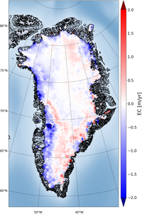
The surface elevation change (SEC) is a direct expression of climate change and is closely linked to the mass balance of the ice sheet. The SEC is a key essential climate variable and is a direct measure of the imbalance between the atmospheric forcing and ice sheet dynamics. In the Greenland CCI project, SEC is derived from present and past ESA radar altimetry missions, and validated by optical data (such as NASA’s IceSat).
The era of ESA altimetry missions was initiated with ERS-1 in 1992, and data from ERS-2, Envisat, CryoSat-2 and Sentinel-3 have contributed to an unbroken time series from then to the present. At present, there are multiple satellites in orbit (Cryosat-2, Sentinel-3A and Sentinel-3B) contributing to the time series; the latter is ensured to be continued, with the operational approach of the EU Sentinel programme.
The nature of the radar measurements enables surface penetration in the interior parts of the Greenland ice sheet and the radar measures a reflecting surface within the upper two meters of the snow cover, rather than the snow-air interface.
As a by-product of the work on SEC products, a Digital Elevation Model for Greenland has also been generated.
Ice Velocity
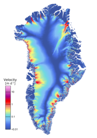
Ice velocity and its spatial derivative strain rate (which is a measure of the ice deformation rate) are key variables for estimating ice discharge and mass balance and are essential input for glacier models that try to quantify ice dynamical processes. Changes in velocity and velocity gradients can point to changing boundary conditions. Remote sensing techniques that utilise SAR and optical satellite data are the only feasible manner to derive accurate surface velocities of the remote Greenland glaciers on a regular basis.
The ice velocity (IV) products generated in the Greenland Ice Sheet CCI are derived from both optical and SAR data using combinations of different techniques. Details of the methods are provided in the Algorithm Theoretical Basis Document (ATBD).
Ice velocity is provided as gridded velocity fields (maps) in NetCDF format with separate files for x and y velocity components (in m/d). The velocity represents a mean velocity value over a time period ranging from the time span of the satellite repeat cycle (between 1 to 46 days) to a full season or year for the ice sheet-wide velocity maps.
Grounding Line Location
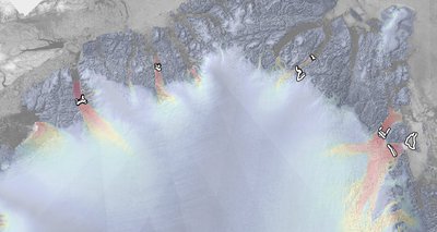
The grounding line location (GLL) marks the position where an ice sheet or marine-terminating glacier starts to float. Understanding the processes at the grounding line of outlet glaciers is important in order to predict the response of the ice to changing boundary conditions and to establish realistic future scenarios in response to climate change.
Remote sensing observations do not provide direct measurements of the grounding line position but can be used to detect the tidal flexure zone, using InSAR data, or spatial changes in texture and shading, using optical images, which are indicators of the transition from grounded to floating ice. Due to the plasticity of ice, these indicators usually spread out over a zone upstream and downstream of the actual grounding line, also called the grounding zone.
In the Greenland Ice Sheet CCI, the GLL is derived from InSAR data by mapping the tidal flexure zone visible in interferograms. It is generated for selected glaciers with a floating ice tongue.
Click here to browse and download Grounding Line Location products
Products by ENVEO are also available directly from http://cryoportal.enveo.at/.
Gravimetric Mass Balance
The Gravity Recovery and Climate Experiment (GRACE) twin satellites have been measuring changes in the Earth’s gravitational field between 2002 and 2017. Its follow-on mission GRACE-FO continues the time series since 2018. Time-variable gravity fields can be used to infer mass changes and mass redistributions in the Earth’s subsystems (e.g. the cryosphere). Mass variations of the Greenland Ice Sheet (GIS) can be measured with an accuracy of around 20 Gt/yr. In order to meet the IGOS (Integrated Global Observing Strategy) requirements as outlined in the GCOS-154 document systematic observation requirements for satellite-based data products for climate - 2011 Update: Supplemental details to the satellite-based component of the “Implementation Plan for the Global Observing System for Climate in Support of the UNFCCC (2010 Update)”, the Greenland Ice Sheet cci (GIS_cci) produces li Mass Balance (GMB) products for the Greenland Ice Sheet from GRACE and GRACE-FO measurements. These products comprise monthly mass change time series for the entire GIS and different drainage basins as well as gridded mass change trends over different 5-year periods between.
GRACE/GRACE-FO data are available from different processing centres, including the Center for Space Research (CSR) at University of Texas, and the GeoForschungsZentrum (GFZ). Here, we use the CSR RL06 solution series (http://www2.csr.utexas.edu/grace/RL06.html), which includes spherical harmonic coefficients up to degree lmax=96.
Monthly spherical harmonic coefficients of changes in the Earth’s gravity field are available for the mission period. Different processing algorithms exist in order to derive the required information from the available data for the GIS. The round robin (RR) exercise carried out during the second phase of GIS_cci by TU Dresden has confirmed that the mass inversion and spherical harmonic filtering methods give comparable results.
The GIS GMB setup is primarily based on the inversion method, applied by DTU Space, where a direct estimate of mass changes are done in a direct least-squares generalized inverse processing. The choice of this method secures consistency with the current Danish Polar Portal data (http://polarportal.dk). Details of the inversion method is outlined in the ATBD document. In addition, a second GMB product based on the regional integration approach using tailored sensitivity kernels is provided by TU Dresden.
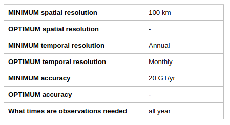
As specified in the User Requirements Document (URD), user requirements for a gravimetric mass balance product (GMB) were found through a user survey for the Antarctic Ice Sheet cci (AIS_cci). The results were adopted for the GIS_cci. The product requirements for the GMB product are outlined below:
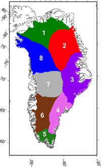
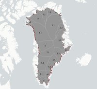
The drainage basins used are an aggregation of those described by Zwally et al. (2012). The figure below shows the outline of the basins. They are also employed for the GMB RR exercise.
Click here to browse and download Gravimetric Mass Balance products.
Products by TU Dresden are also available directly from https://data1.geo.tu-dresden.de/gis_gmb/.
Mass Flow rate Ice Discharge
The mass flow rate and ice discharge (MFID) product generated in the Greenland Ice Sheet CCI are derived from the CCI ice velocity (IV) product, the CCI surface elevation change (SEC) product, and ice thickness from BedMachine. Ice discharge gates are placed 10km upstream from all marine terminating glacier termini that have baseline velocities of more than 150 m/yr. Results are summed by Zwally et al. (2012) sectors. Full details of the methods are provided in the Algorithm Theorotical Basis Document (ATBD) or in Mankoff et al. (2019).
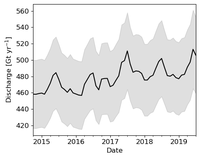
The following figure shows the sectors and gate locations within each sector.
MFID is provided as a time series CSV file where each column represents one sector from with units in Gt/yr. Additional files provide error estimates and coverage (a measure of gap-filling).
Click here to browse and download Mass-Flow rate Ice Discharge products.
The product is generated by GEUS.
Supraglacial Lakes
Supraglacial Lakes (SGL) are meltwater lakes that form in depressions at the surface of the ice sheet in the ablation zone. Supraglacial lakes are indicators of surface melt and are a major component of the routing and storage of meltwater at the ice sheet surface. These play an important role in the delivery of meltwater to the base of the ice sheet. The delivery of water to the base of glaciers and ice sheets has been observed to influence basal sliding on a range of spatiotemporal scales, as well as play a pivotal role in the seasonal evolution of the subglacial drainage system.
A new R&D SGL product is currently under development by S&T. It will be generated by a deep learning-based model combining ICESat-2 and Sentinel-2 data. More specifically, this new ECV will be a dataset containing lake extent and lake depth estimates for the 2019 meltwater season within the two catchment areas in North-East Greenland (79 and Zacharia). If successful, the model may be rolled out onto other areas where there are sufficient labels, such as southwest Greenland.
The dataset will be generated using a deep learning algorithm which uses a U-Net architecture (Ronneberger et al., 2015) which is trained on Sentinel-2 optical imagery, lake extent labels and partial lake depth labels (mentioned below). The algorithm is trained to “learn” features of the optical imagery in order to predict lake extent and depth.
Click here to browse and download SupraGlacial Lakes products.
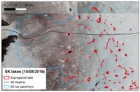
The SGLs can also be derived using more traditional methodologies. During the first phase of the project, a prof-of-concept for a new R&D product was developed. It was derived from Sentinel-2 optical data using an automated Normalised Difference Water Index (NDWI). These products are produced for selected regions of interest, and version 1.1 is for the Sermeq Kujalleq (Jakobshavn Isbrae) hydrological catchment, as defined by Mankoff et al. 2020. The lake outlines are stored as standard vectorised polygons, with additional metadata stored in the attribute table. The detected lakes are filtered according to maximum recorded surface area and a mask of SGL basins from DEM sink filling is applied to remove false positives.
A more detailed description of the product, including an analysis of elevation and individual lakes, is available in the product report.
The product was an R&D CCI+ activity and it was generated by Asiaq (Greenland).
Calving Front Location
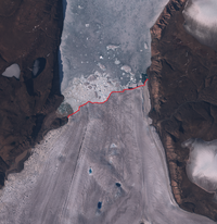
The Calving Front Location (CFL) of outlet glaciers from ice sheets is a basic parameter for ice dynamic modelling, computing mass fluxes and mapping glacier area change. From the ice velocity at the calving front and a time sequence of Calving Front Locations, the iceberg production rate can be computed, which is of relevance for estimating the export of ice mass to the ocean.
The CFL product is generated by a deep learning-based model using optical satellite imagery (Sentinel-2). The digitized calving front is stored as vector lines in standard GeoJSON files. Additionally, metadata information on the sensor and processing steps are stored in corresponding attributes in the GeoJSON files. GeoJSON is an open standard format designed for representing simple geographical features (points, line strings, polygons, and collections), along with their non-spatial attributes.
Click here to browse and download Calving Front Location products
Products by Science [&] Technology AS.
The CFL can also be derived by manual delineation using SAR and optical satellite data. The digitised calving front is stored as vector lines in standard GIS format. Additionally, metadata information on the sensor and processing steps are stored in the corresponding attribute table. In accordance with the URD, the vector files are provided in ESRI shape-file format. This product is currently not in production.
Click here to browse and download Calving Front Location products
Products by ENVEO are also available directly from http://cryoportal.enveo.at.
Key Documents
Team
The Ice Sheets project team comprises nine scientific and industrial partners from Denmark, Norway, UK, Greenland, Germany and Austria.
The team is organised as follows:
- Project Lead and Scientific Lead – The Danish Technical University, Space Department (DTU Space). The project’s Science Lead is Louise Sandberg Sørensen.
- Technical Project Management – Science [&] Technology AS (S[&]T)
- Earth Observation Science Team – led by ENVironmental Earth Observation IT GmbH (ENVEO)
- Systems Engineering Team – led by S[&]T in collaboration with ENVEO
- Climate Research Group – chaired by Dr Ruth Mottram (DMIS)
DTU Space is the project leader, responsible for the scientific coordination of the project, relations with ESA and communicating about the project to relevant scientific communities. DTU Space participates in this project with two divisions; the Geodynamics Department (DTU-GDK) and the Microwaves and Remote Sensing Department (DTU-MRS). Both these divisions have extensive experience with research projects concerning the Greenland ice sheet, and with processing of all relevant data sets (SAR and radar altimetry). DTU-GDK is also leading the scientific data processor development of the Surface Elevation Change (SEC) parameter.
S[&]T is responsible for the Ice Sheets CCI technical project management. It leads the development of the Optical Ice Velocity (Opt-IV) and of the machine learning-based Supraglacial Lakes extent (SGL) parameter.
ASIAQ Greenland survey is a public enterprise owned by the Government of Greenland and administered by the Ministry of Mineral Resources. It leads the validation and inter-comparison activity of all ECVs.
Danish Meteorological Institute (DMI) with its Danish Climate Centre department, as an involved end-user, is leading the ECV product delivery to the climate and ice sheet models, as well as contributing to the user requirements analysis and the user assessment activities.
ENVEO is leading the development of the algorithms, including scientific data processor development regarding the SAR Ice Velocity (IV) parameters. They are participating in the Systems Engineering team, leading the EO Science team and supporting validation using optical data.
GEUS (The Geological Survey of Denmark and Greenland) is leading the product validation. GEUS also develops and produces the Mass Flow Rate and Ice Discharge (MFID) ECV.
Niels Bohr Institute (NBI) is leading the user requirements analysis and participating in the user assessment and ECV product delivery to modelling community tasks.
Technische Universität Dresden (TUDr) is co-leading the scientific data processor development of the Gravimetric Mass Balance (GMB) parameter including the Full Round Robin activity.
Northumbria University is contributing to the product validation and inter-comparison activity.
The Climate Research Group
The Climate Research Group (CRG) is a group of expert individuals associated with the Ice Sheets CCI. They are involved in understanding climate dynamics specifically related to the Ice Sheets Essential Climate Variables.
The CGR is headed by Dr Ruth Mottram who is a glaciologist and climate scientist at the Danish Meteological Institute, with a focus on the interaction between atmosphere, ocean and ice sheet, especially developing the HIRHAM suite of models. She is leading the Greenland part of EU project PROTECT 2020-24.
The following internationally renowned experts make up the rest of the CRG team:
- Dr Sofie Nowicki, University of Buffalo, USA: Ice sheet modeler, co-lead of ISMIP-6. Formerly researcher and deputy chief, NASA GSFC Cryosphere Lab.
- Karl Zinglersen, GIS and geospatial coordinator, Pinngortitaleriffik/Greenland Nature Institute, and member of DCE/GN joint data center for Nature and Environment
- Prof. Gudfinna Adalgeirsdottir, University of Iceland, a leading coupled ice/climate modeller and partner of several earlier EU and Nordic cryosphere projects.
Publications
- Valentina R. Barletta, Andrea Bordoni, Shfaqat Abbas Khan. GNET Derived Mass Balance and Glacial Isostatic Adjustment Constraints for Greenland. Geophysical Research Letters. 2024. https://doi.org/10.1029/2023GL106891
- Thomas Slater, Inès N. Otosaka, Andrew Shepherd, Jan Wuite, Thomas Nagler, Lukas Krieger, Dana Floricioiu, Sainan Sun, Ben Davison and Anna E. Hogg. A fine resolution mass budget of the Antarctic Ice Sheet. Geophysical Research Letters. 2024, Under Review.
- Richard Parsons, Sainan Sun, G. Hilmar Gudmundsson, Jan Wuite, and Thomas Nagler. Quantifying the Buttressing Contribution of Sea Ice to Crane Glacier. The Cryosphere. 2024, Accepted. http://dx.doi.org/10.5194/egusphere-2024-1499
- Nitin Ravinder, Inès N. Otosaka, Andrew Shepherd, Thomas Slater, Alan Mur, Lin Gilbert. Greenland Ice Sheet Elevation Change from CryoSat-2 and ICESat-2. Geophysical Research Letters. 2024, Submitted.
- Khosro Ghobadi-Far, Susanna Werth, Manoochehr Shirzaei, Bryant D. Loomis, Thorben Döhne, Matthias O. Willen, Martin Horwath. The Impact of New Accelerometer Transplant Data (ACH) on GRACE Follow-On Along-Orbit Inter-Satellite Laser Ranging Observations and Monthly Time-Variable Gravity and Mascon Solutions. Journal of Geophysical Research: Solid Earth. 2023. https://doi.org/10.1029/2023JB026740
- Otosaka, I. N., Horwath, M., Mottram, R., & Nowicki, S. Mass balances of the Antarctic and Greenland ice sheets monitored from space. Surveys in Geophysics. 2023. https://doi.org/10.1007/s10712-023-09795-8
- Danjal Berg, Valentina Barletta, et al.. Vertical land motion due to present-day ice loss from Greenland's and Canada's peripheral glaciers. AGU Geophysical Research Letters. 2023. https://doi.org/10.1029/2023GL104851
- Valentina R Barletta, Andrea Bordoni, Shfaqat Abbas Khan. GNET-derived Mass Balance and Glacial Isostatic Adjustment Constraints for Greenland. AGU GRL. 2023. https://doi.org/10.1029/2023GL106891
- Otosaka et al.. Mass balance of the Greenland and Antarctic ice sheets from 1992 to 2020. Earth System Science Data. 2023. http://doi.org/10.5194/essd-2022-261
- Abigail Elizabeth Robinson, David Völgyes, Martijn Vermeer, Daniele Stefano Maria Fantin, Louise Sandberg Sørensen, Mikkel Aaby Kruse, & Sabine Frosch. Deep learning-based supraglacial lake extent and depth detection on the Greenland Ice Sheet by combining ICESat-2 and Sentinel-2 data. Global Space Conference on climate change 2023. 2023. https://doi.org/10.5281/zenodo.7981531
- Jonas Kvist Andersen, Nicholas Mossor Rathmann, Christine S. Hvidberg, Aslak Grinsted, Anders Kusk, John Peter Merryman Boncori, Jeremie Mouginot. Episodic Subglacial Drainage Outbursts Below the Northeast Greenland Ice Stream. Geophysical Research Letters. 2023. https://doi.org/10.1029/2023GL103240
- Karina von Schuckmann, Audrey Minière, Flora Gues, Francisco José Cuesta-Valero et al. Heat stored in the Earth system 1960–2020: where does the energy go?. Earth System Science Data. 2023. https://doi.org/10.5194/essd-15-1675-2023
- Nicolaj Hansen, Louise Sandberg Sorensen, Giorgio Spada, Daniele Melini, Rene Forsberg, Ruth Mottram, and Sebastian B. Simonsen. Revisiting ice sheet Mass balance: insights into changing dynamics in Greenland and Antarctica from ICESat-2. The Cryosphere Discussions. 2023.
- Thorben Döhne, Martin Horwath, Andreas Groh & Eric Buchta. The sensitivity kernel perspective on GRACE mass change estimates. Journal of Geodesy. 2023. https://doi.org/10.1007/s00190-022-01697-8
- Nathan Maier, Jonas Kvist Andersen, Jérémie Mouginot, Florent Gimbert, Olivier Gagliardini. Wintertime Supraglacial Lake Drainage Cascade Triggers Large-Scale Ice Flow Response in Greenland. Geophysical Research Letters. 2022. https://doi.org/10.1029/2022GL102251
- T. Nagler, L. Libert, J. Wuite, M. Hetzenecker, L. Keuris and H. Rott. Comprehensive Ice sheet wide velocity mapping combining SAR interferometry and offset tracking. IGARSS 2022 - 2022 IEEE International Geoscience and Remote Sensing Symposium. 2022. https://doi.org/10.1109/IGARSS46834.2022.9884206
- Ines Otosaka and the IMBIE team. Mass balance of the Greenland and Antarctic ice sheets from 1992 to 2020. Earth System Science Data. 2022. https://doi.org/10.5194/essd-2022-261
- Martin Horwath, Benjamin D. Gutknecht, Anny Cazenave, Hindumathi Kulaiappan Palanisamy et al. Global sea-level budget and ocean-mass budget, with a focus on advanced data products and uncertainty characterisation. Earth System Science Data. 2022. https://doi.org/10.5194/essd-14-411-2022
- Sebastian B. Simonsen, Valentina R. Barletta, William T. Colgan, Louise Sandberg Sørensen. Greenland Ice Sheet mass balance (1992–2020) from calibrated radar altimetry. Geophysical Research Letters. 2021. https://doi.org/10.1029/2020GL091216
- Nathan Maier, Jonas Kvist Andersen, Jérémie Mouginot, Florent Gimbert, Olivier Gagliardini. Burst Overlap Coregistration for Sentinel-1 TOPS DInSAR Ice Velocity Measurements. IEEE Geoscience and Remote Sensing Letters. 2021. https://doi.org/10.1109/LGRS.2021.3062905
- Thomas Nagler, Jan Wuite, Ludivine Libert et al.. Continuous Monitoring of Ice Motion and Discharge of Antarctic and Greenland Ice Sheets and Outlet Glaciers by Sentinel-1 A & B. 2021 IEEE International Geoscience and Remote Sensing Symposium IGARSS. 2021. https://doi.org/10.1109/IGARSS47720.2021.9553514
- Maria T. Kappelsberger, Undine Strößenreuther, Mirko Scheinert, Martin Horwath et al.hfaqat A. Khan. Modeled and observed bedrock displacements in north-east Greenland using refined estimates of present-day ice-mass changes and densified GNSS measurements. Journal of Geophysical Research - Earth Surface. 2021. https://doi.org/10.1029/2020JF005860
- Bramha Dutt Vishwakarma, Martin Horwath, Andreas Groh, Jonathan L Bamber. Accounting for GIA signal in GRACE products. Geophysical Journal International. 2021. https://doi.org/10.1093/gji/ggab464
- Winton, Ø, Simonsen, S., Solgaard, A., McNabb, R., & Karlsson, N.. Basal stress controls ice-flow variability during a surge cycle of Hagen Bræ, Greenland. Journal of Glaciology. 2021. https://doi.org/10.1017/jog.2021.111
- Kenneth D. Mankoff, Xavier Fettweis, Peter L. Langen, Martin Stendel et al.. Greenland ice sheet mass balance from 1840 through next week. Earth System Science Data. 2021. https://doi.org/10.5194/essd-13-5001-2021
News and events
Related links
Click on the following links for publications relating to the Greenland Ice Sheet project.
Websites related to the Greenland Ice Sheet CCI Project
- Antarctic Ice Sheet project
- ECV Wiki
- Sharing Observations for Climate Research
Other websites related to ice sheets
- North Greenland Eemian Ice Drilling
- Past-4-Future
- NCoE SVALI
- Greenland Climate Research Center
- Center for Regional Change in the Earth System
Relevant tools to the Greenland Ice Sheet CCI Project
Contacts
The following people can be contacted within the Greenland Ice Sheet project.
Project leaders:
- Science Leader: Louise Sørensen (DTU-S) – slss@space.dtu.dk
- Project Manager: Daniele Fantin (S&T) – fantin@stcorp.no
Climate Research Group Lead: Ruth Mottram (DMI) – rum@dmi.dk
Website administration: Andreas Thorvaldsen (S&T) – thorvaldsen@stcorp.no
Latest news & events

Working for ESA: procurement and proposal submission process
An Introduction to ESA Star - ESA's System for Tendering and Registration
En savoir plus
ESA at COP29
ESA is participating in COP29 to highlighting satellites' role in tackling climate change
En savoir plus

Call for new projects: Additional Essential Climate Variables
New R&D procurement as part of ESA's CLIMATE-SPACE programme
En savoir plus
Open Competitive Tender for CLIMATE-SPACE Knowledge Exchange
ESA Tender Action Number: 1-12141. ESA Activity Number: 1000039650.
En savoir plus
Satellites a ‘clear opportunity’ for forewarning of climate tipping points
New research offers guidance on how remote sensing can help understand and detection tipping systems
En savoir plus
Little Pictures winner announced at COP28
Results of Europe-wide climate data visualisation showcased
En savoir plus
New Tender: CROSS-ECV ACTIVITIES Tender Action Number: 1-12062
New tender issued by the ESA Climate Office (Activity Number: 1000039196)
En savoir plus
Harnessing Earth Observation for Climate Action
ESA in conversation Prof Jim Skea with IPCC Chair during the COP28 Earth Information day
En savoir plus
COP28: ESA Climate Office events
The Climate Office is contributing to several events at COP28, UAE, Dubai
En savoir plus
Taking climate action with Earth observation
Satellites' contribution to understanding climate change and supporting climate action are under the COP28 spotlight
En savoir plus
Climate Change Initiative colocation CMUG Integration meetings 2023
7-9 November 2023
En savoir plus


